Lei Yue Mun – Unique Coastline
Lyemun Pass
Lyemun Pass is geographically unique, located at the eastern entrance of Victoria Harbour, separating Sam Ka Tsuen in Kowloon the north from the northeastern coast of Hong Kong Island in the south shore of the harbour. Despite its narrow width of approximately 420 meters, it has a depth up to approximately 43 meters, making it the deepest navigation waterway in Victoria Harbour and allowing large vessels with carrying capacity 100,000 tons to pass through smoothly. Lyemun Pass, with a strategic location, therefore has also been playing an important role in Hong Kong's trade development.
Architectural Features of Lei Yue Mun
Lei Yue Mun is abundant in granite stone. The Hakka people who settled there built single-storey buildings by using the granite stones (commonly known as "cow stone") from the Lei Yue Mun Quarry to form walls with pitched roofs made of timber poles covered by tiles.
In the early 1960s, there was a rapid increase in the population of people who fled from Guangdong and migrated to Lei Yue Mun Village. To meet housing demands, some villagers built squatters on the hillside at the back of the village. At the same time, villagers demolished single-storey old buildings and replaced them with three-storey reinforced concrete buildings.
Around 1964, some villagers residing by the sea began constructing bridges or stilted houses by using timber poles or concrete pillars on rock outcrop along the coastal shores of Lei Yue Mun. The bridges were used by fishmonger while the stilted houses that appeared to float on the water served as residences or seafood restaurants which became a special feature of Lei Yue Mun buildings. Even today, you can still find residents and businesses in operation on some of the remaining stilted houses in Lei Yue Mun.
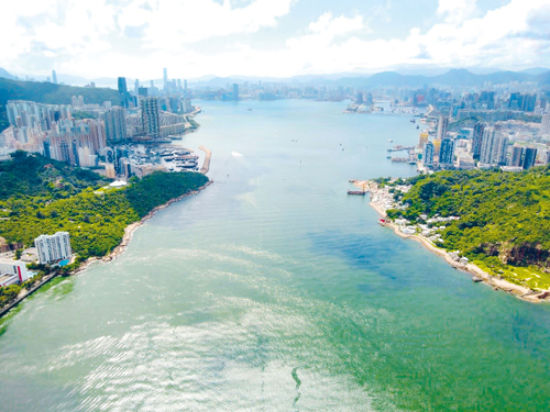 Bird’s eye view of Lei Yue Mun in 2023
(Photo source: Dr. Poon Sun Wah)
(Photo source: Dr. Poon Sun Wah)
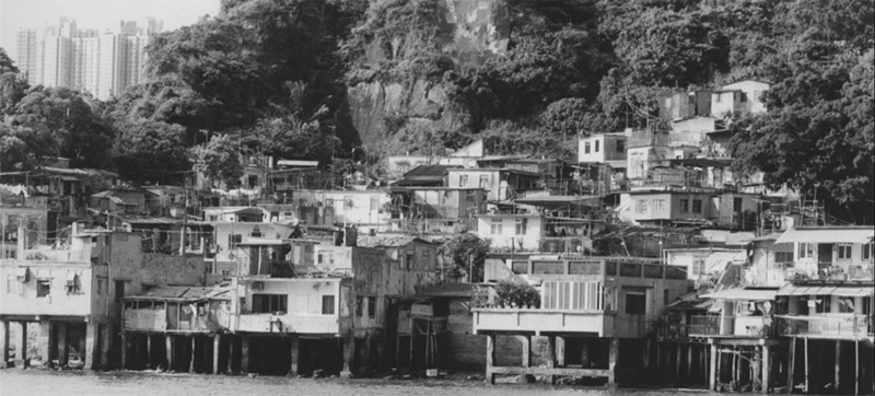 Stilted Houses along Lei Yue Mun Coastline in 1993
(Photo source: University of Hong Kong Library)
(Photo source: University of Hong Kong Library)
Due to the low-lying topographical characteristics of Lei Yue Mun Village, with elevation of about 2.85 meters to 4.75 meters above the chart datum, areas such as Ma Wan Village are particularly susceptible to storm surges and high waves. If storm surge occurs during astronomical high tide, the sea can rise to a high level and cause flooding in low-lying coastal areas. For example, during the typhoons "Wanda" in 1962, "Hato" in 2017, and "Mangkhut" in 2018, the water level rose above the chart datum at 3.57 meters to 3.96 meters, resulting in significant property damage in Lei Yue Mun Village. To reduce damage arising from flooding, the government has installed demountable flood barriers at building frontages in need to reduce the risks of seawater getting into their houses. Additionally, in the southern coastal area, rock-armoured bunds/gabion walls, and concrete flood walls have been built to alleviate the influx of wave into the village.
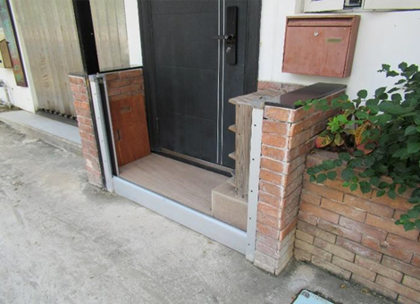 Demountable flood barrier installed at building frontages
(Photo source: Dr. Poon Sun Wah)
(Photo source: Dr. Poon Sun Wah)
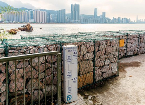 Record of Water Levels at Lei Yue Mun Village during typhoons
 (Photo source: Drainage Services Department)
(Photo source: Drainage Services Department)